联系我们
填写以下表单联系我们
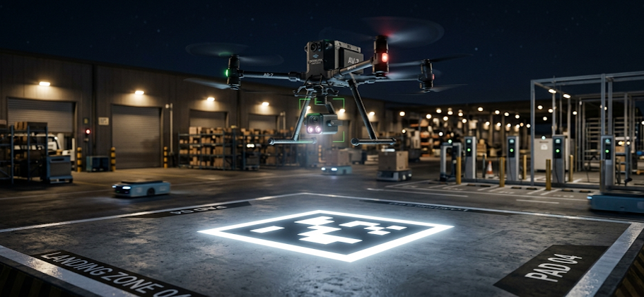
Consider a typical industrial scenario: After completing scheduled distribution missions, an autonomous delivery drone initiates an automatic return procedure to the logistics hub and is required to land stably on a charging platform with a width of merely several tens of centimeters. Upon landing, the drone needs to achieve precise alignment with charging contacts to support automatic power replenishment and standby for subsequent operational tasks.
Such precision maneuvering is feasible for human pilots yet remains a core technical challenge for unmanned aerial vehicles (UAVs). Although modern UAVs can realize kilometer-level autonomous cruise via integrated GPS, Real-Time Kinematic (RTK), and inertial navigation systems, positioning precision becomes a major technical bottleneck during the final short-range landing phase.
Conventional GPS systems deliver a positioning error ranging from 1 to 5 meters. Even high-precision RTK navigation cannot eliminate errors of several centimeters to tens of centimeters. For autonomous operational scenarios including automatic charging, intelligent battery swapping, and unmanned cargo loading, such residual errors are unacceptable and fail to meet industrial precision requirements.
Accordingly, the drone industry has widely adopted Visual Terminal Guidance (VTG) as a mainstream solution for precise terminal positioning. The technical logic is straightforward: satellite navigation guides the UAV to the vicinity of the target base, while the machine vision system undertakes high-precision positioning and trajectory correction for the final landing phase.
The key to autonomous precision landing lies in visual marker positioning technology. Specially designed artificial visual markers are deployed on the ground at the landing site. The UAV’s onboard vision sensor captures real-time images of the markers, resolves their spatial position and pose information, and feeds valid data back to the flight controller. The flight control system then dynamically corrects the flight trajectory, ultimately achieving centimeter-level landing accuracy.
Visually similar to QR codes, these markers are not designed for data storage. Instead, they belong to dedicated fiducial marker systems optimized for machine vision positioning. Typical industrial visual marker solutions include:
These visual fiducial markers have been widely deployed across multiple intelligent robotic application scenarios:
Industrial-grade UAV visual markers must possess comprehensive environmental adaptability and detection performance, covering the following core capabilities:
When the onboard camera acquires marker images, the visual algorithm automatically extracts marker boundaries and key feature points. Based on the inherent geometric parameters of the markers, the system solves real-time spatial state data, including:
In essence, the vision system enables the UAV to acquire not only the absolute position of the target but also the relative pose relationship between the aircraft and the landing point, which constitutes the core premise for autonomous precision landing.
The entire autonomous return and landing process can be standardized into three sequential operational phases, realizing seamless switching from satellite navigation to visual closed-loop control.
The UAV adopts GPS or RTK satellite navigation to complete long-distance cruise and return to the airspace near the target landing base. The meter-level positioning accuracy of satellite navigation is sufficient to support large-scale regional navigation requirements in this phase.
When the UAV enters the preset visual detection airspace above the target site, the onboard vision system activates and performs real-time searching and scanning of ground visual markers. Once a valid marker is detected, the system automatically completes a series of algorithmic operations, including marker identification, identity verification, feature point extraction, and aircraft pose solving. Subsequently, the UAV completes the mode transition from satellite navigation to visual guidance.
The flight control system continuously calculates multi-dimensional deviation data, including X-axis horizontal deviation, Y-axis horizontal deviation, rotational angle deviation, and altitude deviation. The system corrects the flight trajectory at a high frequency of tens to hundreds of times per second, realizing dynamic convergence to the target center. In practical industrial engineering deployments, the visual guidance solution can stably achieve a landing accuracy of ±5 cm, with optimal working conditions supporting ±1 cm ultra-precision landing.
Visual marker recognition exhibits stable performance under sufficient daylight illumination. The core environmental challenges for the system include night scenarios, rain and fog weather, shadow occlusion, and low-illumination environments. Conventional printed visual markers suffer from severely attenuated recognition distance and reduced detection stability under complex conditions.
To address this pain point, mainstream industrial UAV platforms adopt retroreflective materials for visual marker fabrication, significantly enhancing the environmental adaptability of visual positioning systems.
Retroreflective materials are mature functional materials widely applied in traffic signage and road safety facilities. Their core physical characteristic is reflecting incident light back to the light source along an approximate original optical path. For UAV visual systems, this feature enables the light emitted by the onboard fill light module to be efficiently reflected to the camera sensor, forming an ultra-high-contrast imaging effect. In captured images, the retroreflective marker presents an active luminous state, supporting stable and reliable recognition even at an altitude of tens of meters.
Industrial high-stability visual markers adopt a three-layer composite structural design:
When irradiated by the UAV’s infrared fill light source, the reflective area presents a high-brightness state, while the patterned functional area maintains low-dark features, forming a high-distinction black-and-white visual feature. This structural optimization effectively improves night recognition distance, anti-interference capability, operational stability, and overall positioning accuracy of the system.
With the iterative development of UAV autonomous intelligence technology, future solutions may realize natural scene positioning based on building features, road topography, and geographic landforms via artificial vision algorithms. Nevertheless, visual marker positioning remains one of the most mature, reliable, and cost-effective terminal precision landing solutions for current industrial engineering applications.
Analogous to navigation beacons at airport runways, satellite navigation systems complete macroscopic homing for UAVs, while visual markers provide microscopic, high-precision positioning references for terminal landing. Driven by the rapid development of urban low-altitude economy, intelligent logistics distribution, and automated inspection scenarios, these standardized visual marker patterns have evolved into essential foundational infrastructure for large-scale commercial UAV operations.
Please contact us, and we will respond to you shortly.
Contact UsInfrared transmitting plastics & optical materials for machine vision
Copyright ©2026 Visualplas Technology